Imja Valley, Nepal: Complete Travel & Trekking Guide
By Nepal Trip Services On 08 Oct 2026
By Nepal Trip Services On 08 Oct 2026

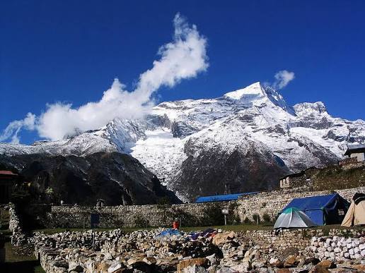
The Imja Valley is a high Himalayan valley in Nepal's Everest (Khumbu) region, running east from Pangboche past Dingboche to Chhukung and the foot of Island Peak. It is enclosed by some of the most dramatic mountain walls on Earth: the vast south face of Lhotse to the north, Ama Dablam to the south and Makalu peeking over the eastern ridges. Glaciers, moraine and the milky Imja Khola river shape a landscape that feels raw, open and utterly Himalayan.
Most trekkers meet the Imja Valley at Dingboche, the main acclimatisation stop on the Classic Everest Base Camp Trek. Fewer continue up to Chhukung, the glacial lake Imja Tsho and Island Peak Base Camp, or cross Kongma La on the Everest Three High Passes Trek. Those who do discover one of the quietest and most rewarding corners of the Khumbu.
This guide covers everything you need to plan a visit: location, how to get there, the best places to see, sample itineraries, difficulty, seasons, permits, teahouses and packing, followed by the 15 questions trekkers ask most.
|
Detail |
Information |
|---|---|
|
Location |
Khumbu region, Sagarmatha National Park, Solukhumbu District, Koshi Province, Nepal |
|
Valley span |
Pangboche (~3,930 m) → Dingboche (4,410 m) → Chhukung (~4,730 m) → Island Peak Base Camp (~5,090 m) |
|
River |
Imja Khola, fed by the Imja and Lhotse glaciers |
|
Main villages |
Dingboche, Bibre, Chhukung |
|
Highlights |
Nangkartshang viewpoint, Chhukung Ri, Imja Tsho lake, Island Peak, Kongma La |
|
Highest trekking viewpoint |
Chhukung Ri (~5,550 m) |
|
Major peaks |
Lhotse (8,516 m), Makalu (8,485 m), Ama Dablam (6,812 m), Island Peak (6,189 m), Baruntse (7,129 m) |
|
Difficulty |
Moderate to strenuous (altitude is the main challenge) |
|
Best seasons |
March–May and late September–November |
|
Accommodation |
Teahouses in Dingboche, Bibre and Chhukung |
|
Permits |
Sagarmatha National Park + Khumbu Pasang Lhamu Rural Municipality |
|
Treks that visit |
Classic Everest Base Camp Trek, Everest Three High Passes Trek and custom Chhukung or Island Peak trips |
The Imja Valley lies inside Sagarmatha National Park, a UNESCO World Heritage Site in northeastern Nepal. Above Pangboche, the main Everest trail splits in two: the left branch follows the Khumbu Khola to Pheriche, Lobuche and Everest Base Camp, while the right branch climbs east along the Imja Khola into the Imja Valley. The two valleys are separated by the Nangkartshang ridge and reconnected high up by the Kongma La pass.
There are no roads in the Khumbu, so the Imja Valley is reached on foot after a mountain flight to Lukla.
Helicopter option: short helicopter sightseeing flights over the Khumbu are possible through our helicopter services, but flying straight to 4,400 m+ without acclimatisation is unsafe for overnight stays.
|
Trek |
Duration |
Imja Valley stops |
Price from |
|---|---|---|---|
|
14 days |
2 nights in Dingboche with an acclimatisation hike |
US$ 1,200 per person |
|
|
19 days |
Dingboche (2 nights) and Chhukung, then Kongma La |
US$ 1,450 per person |
|
|
Chhukung & Imja Valley extension (custom) |
15–16 days |
Dingboche, Chhukung, Chhukung Ri and Imja Tsho, added to EBC |
On request |
|
Island Peak climbing (custom) |
17–19 days |
Chhukung, Island Peak Base Camp and summit (6,189 m) |
On request |
See every route on our Everest Region Treks page.
Dingboche is the largest settlement in the valley and one of the most important acclimatisation stops in the Everest region. Its patchwork of stone-walled barley and potato fields, built to shield crops from fierce winds, sits beneath Ama Dablam and the towering Lhotse–Nuptse wall. Lodges here are surprisingly comfortable, with bakeries, cafés and Wi-Fi.
The ridge directly above Dingboche, also known locally as Nagarjun Hill, is the standard climb-high, sleep-low hike for EBC and Three Passes trekkers. The 3–4 hour round trip rewards you with a sweeping panorama of Makalu (8,485 m), Lhotse, Ama Dablam, Island Peak and the entire Imja Valley.
Between Dingboche and Chhukung, the tiny seasonal settlement of Bibre sits among open yak pastures and stone huts. It is a peaceful spot for tea and a rest, with Ama Dablam's north face looming directly overhead.
Chhukung is a cluster of lodges at the head of the inhabited valley, surrounded by glaciers and giant walls of rock and ice. It is the base for Chhukung Ri, Imja Tsho, Island Peak and Kongma La, and one of the quietest overnight stops in the Khumbu.
This rocky summit above Chhukung is one of the highest non-technical viewpoints in Nepal, similar in height to Kala Patthar. The steep 3–4 hour climb reveals Lhotse's south face at startling close range, along with Makalu, Baruntse, Ama Dablam, Island Peak and the Imja and Lhotse glaciers. Many trekkers climb it as a final acclimatisation hike before Kongma La or Island Peak.
At the foot of the Imja Glacier lies Imja Tsho, a grey-green glacial lake roughly 150 m deep. Its surface area grew from about 0.4 to over 1 km² between 1984 and 2009, making it one of the fastest-growing glacial lakes in Nepal. In 2016, the Nepal Army and local workers, supported by the UNDP, cut an outlet channel and lowered the water level by about 3.4 m to reduce flood risk downstream. A visit here is a powerful lesson in Himalayan climate change.
Island Peak (Imja Tse, 6,189 m) is Nepal's most popular trekking peak, rising like an island from the glaciers at the head of the valley. Its base camp, a 2–3 hour walk from Chhukung along the moraine, is a rewarding day hike even if you don't plan to climb, with close views of Lhotse Shar, Baruntse and Ama Dablam. Summit climbs need a climbing permit, technical gear and training.
The highest of the Everest Three Passes leaves from Chhukung and crosses into the Khumbu Valley at Lobuche. It is a long, strenuous 8–9 hour day, crossed on our Everest Three High Passes Trek, with frozen lakes, Makalu views and a crossing of the Khumbu Glacier on the far side.
|
Viewpoint |
Altitude |
From |
Round trip |
Difficulty |
Best views |
|---|---|---|---|---|---|
|
Nangkartshang Peak |
~5,083 m |
Dingboche |
3–4 hrs |
Moderate |
Makalu, Lhotse, Ama Dablam |
|
Chhukung Ri |
~5,550 m |
Chhukung |
3–4 hrs |
Challenging |
Lhotse south face, Makalu, Baruntse |
|
Imja Tsho viewpoint |
~5,010 m |
Chhukung |
4–5 hrs |
Moderate |
Imja Glacier, Island Peak, Lhotse Shar |
|
Island Peak Base Camp |
~5,090 m |
Chhukung |
4–6 hrs |
Moderate–challenging |
Island Peak, Baruntse, Ama Dablam |
|
Day |
Route |
Overnight altitude |
|---|---|---|
|
1 |
Arrive in Kathmandu |
1,300 m |
|
2 |
Fly to Lukla, trek to Phakding |
2,610 m |
|
3 |
Phakding → Namche Bazaar |
3,440 m |
|
4 |
Acclimatisation day in Namche |
3,440 m |
|
5 |
Namche → Tengboche |
3,870 m |
|
6 |
Tengboche → Dingboche (enter the Imja Valley) |
4,410 m |
|
7 |
Acclimatisation day: Nangkartshang hike or walk toward Chhukung |
4,410 m |
|
8–14 |
Lobuche → EBC → Kala Patthar → Pheriche → Namche → Lukla → Kathmandu |
— |
Full details: Classic Everest Base Camp Trek itinerary.
This extension adds excellent acclimatisation before Everest Base Camp and some of the finest close-up mountain scenery in Nepal. Ask us to add it through the trip planner.
On the Everest Three High Passes Trek, you spend two nights in Dingboche and one in Chhukung, then cross Kongma La (5,535 m) to Lobuche on day 9 before continuing to EBC, Cho La, Gokyo and Renjo La.
The Imja Valley is one of the best places in the Khumbu to acclimatise, because it lets you climb high on day hikes and sleep lower in Dingboche or Chhukung.
|
Section |
Altitude |
Walking time |
Difficulty |
|---|---|---|---|
|
Tengboche → Dingboche |
3,870 → 4,410 m |
5–6 hrs |
Moderate |
|
Dingboche → Chhukung |
4,410 → ~4,730 m |
2–3 hrs |
Easy–moderate |
|
Nangkartshang hike |
up to ~5,083 m |
3–4 hrs return |
Moderate |
|
Chhukung Ri climb |
up to ~5,550 m |
3–4 hrs return |
Challenging |
|
Chhukung → Island Peak Base Camp |
up to ~5,090 m |
2–3 hrs one way |
Moderate–challenging |
|
Kongma La crossing |
up to 5,535 m |
8–9 hrs |
Strenuous |
The trails themselves are mostly well defined, but altitude makes every step harder. Fit beginners can comfortably reach Dingboche on the Classic EBC trek; Chhukung Ri, Island Peak Base Camp and Kongma La suit trekkers with good fitness and prior high-altitude experience.
The best times to trek the Imja Valley are October–November and March–May, when skies are clear, trails are dry and the peaks stand out sharply.
|
Season |
Months |
Day / night at Dingboche (approx.) |
Conditions |
Verdict |
|---|---|---|---|---|
|
Autumn |
Late Sep–Nov |
8–15°C / -8 to -2°C |
Crystal-clear, stable weather |
Best |
|
Spring |
Mar–May |
8–17°C / -6 to 0°C |
Warmer; Island Peak climbing season; some afternoon cloud |
Excellent |
|
Winter |
Dec–Feb |
0–8°C / -15 to -20°C |
Clear but bitterly cold; some lodges in Chhukung close |
Experienced trekkers only |
|
Monsoon |
Jun–Aug |
10–16°C / 2 to 6°C |
Cloudy, wet, frequent Lukla flight delays |
Least suitable |
Chhukung and the viewpoints above are 5–10°C colder than Dingboche, and wind makes it feel colder still.
No special permit is needed for the Imja Valley itself. The two standard Everest-region permits cover Dingboche, Chhukung, Chhukung Ri, Imja Tsho and Island Peak Base Camp.
|
Permit |
Fee for foreign nationals |
Where checked |
|---|---|---|
|
Sagarmatha National Park Entry Permit |
NPR 3,000 + 13% VAT |
Monjo |
|
Khumbu Pasang Lhamu Rural Municipality Permit |
NPR 3,000 |
Lukla |
|
Island Peak climbing permit (summit only) |
Charged separately by season |
Arranged by your operator |
Both trekking permits are included in all Nepal Trip Services Everest packages. On the trail, budget about US$ 20–30 per day for extras such as hot showers, charging, Wi-Fi, snacks and drinks. There are no ATMs above Namche Bazaar, so carry enough Nepalese rupees.
|
Village |
Altitude |
Teahouse standard |
Facilities |
|---|---|---|---|
|
Dingboche |
4,410 m |
Good |
Many lodges, some attached bathrooms, bakeries, Wi-Fi, solar showers |
|
Bibre |
~4,570 m |
Very basic |
Seasonal tea stops only |
|
Chhukung |
~4,730 m |
Basic |
A handful of lodges, shared toilets, limited hot water, paid charging |
The Imja Valley has long been a summer grazing and farming area for Sherpa families from Pangboche and the lower Khumbu. Many of Dingboche's stone-walled fields still grow barley and potatoes, and yaks graze on the high pastures around Bibre and Chhukung. Along the trail you'll pass mani walls, prayer flags and small chortens, reminders of the Tibetan Buddhist faith that shapes daily life.
Wildlife in the valley includes the Himalayan tahr, pika, and birds such as the Himalayan monal (Danphe), snowcocks, choughs and lammergeiers. The elusive snow leopard lives in Sagarmatha National Park but is very rarely seen.
|
Category |
Essentials |
|---|---|
|
Clothing |
Thermal base layers, fleece, down jacket (rated -15°C to -20°C), waterproof shell jacket and trousers, trekking trousers |
|
Head & hands |
Warm beanie, sun hat, buff, liner and insulated gloves, UV400 glacier sunglasses |
|
Footwear |
Broken-in waterproof boots, camp shoes, wool socks; microspikes for Kongma La or snowy months |
|
Sleeping |
Four-season sleeping bag (-15°C to -20°C) and liner |
|
Gear |
30–40 L daypack, trekking poles, headlamp, insulated water bottles, purification tablets |
|
Health |
Personal medicines, blister kit, rehydration salts, throat lozenges, SPF 50+ sunscreen and lip balm |
|
Electronics |
Power bank, universal adapter, offline maps |
|
Documents |
Passport, insurance details (covering trekking up to 6,000 m), permits, Nepalese rupees |
The Imja Valley's glaciers, lakes and alpine meadows are fragile and directly affected by climate change. Please help protect them:
The Imja Valley is in the Everest (Khumbu) region of Solukhumbu District, inside Sagarmatha National Park. It branches east from the main Everest trail above Pangboche and runs past Dingboche and Chhukung to the glaciers below Lhotse, Island Peak and Baruntse.
The valley rises from about 3,900 m near Pangboche to 4,410 m at Dingboche and around 4,730 m at Chhukung. Viewpoints above it reach about 5,083 m (Nangkartshang), 5,550 m (Chhukung Ri) and 5,535 m at Kongma La.
Fly from Kathmandu (or Ramechhap) to Lukla, then trek via Phakding, Namche Bazaar and Tengboche to Dingboche, usually on day 6 of an Everest Base Camp itinerary. Chhukung is a further 2–3 hours up the valley.
Yes. Dingboche is the largest village and main gateway of the Imja Valley. It is also the key acclimatisation stop on the Classic Everest Base Camp Trek, with two nights spent there.
Highlights include the stone-walled fields of Dingboche, the Nangkartshang viewpoint, Chhukung village, Chhukung Ri, the glacial lake Imja Tsho, Island Peak Base Camp and Kongma La Pass. The scenery is dominated by Lhotse's south face, Ama Dablam, Makalu, Baruntse and Island Peak.
On a standard EBC trek, you spend two nights in Dingboche. To properly explore Chhukung, Chhukung Ri and Imja Tsho, add 2–3 extra days. The Everest Three High Passes Trek includes two nights in Dingboche and one in Chhukung.
Walking to Dingboche and Chhukung is moderate, but altitude makes it demanding. Side trips to Chhukung Ri, Island Peak Base Camp and Kongma La are challenging to strenuous and suit trekkers with good fitness and previous high-altitude experience.
Chhukung Ri (~5,550 m) is a rocky viewpoint above Chhukung, about the same height as Kala Patthar. The climb takes 3–4 hours return on a steep, rocky trail, with the last section involving easy scrambling. It offers one of the closest views of Lhotse's south face available to trekkers.
Imja Tsho (~5,010 m) is a large glacial lake at the snout of the Imja Glacier, around 150 m deep. It grew rapidly from about 0.4 to over 1 km² between 1984 and 2009. In 2016, the Nepal Army lowered its water level by about 3.4 m to reduce the risk of a glacial lake outburst flood.
Yes. Island Peak Base Camp (~5,090 m) is a 2–3 hour walk from Chhukung and makes a rewarding day hike for well-acclimatised trekkers. You don't need a climbing permit to visit base camp, only the standard trekking permits.
No. The Sagarmatha National Park permit and the Khumbu Pasang Lhamu Rural Municipality permit cover the whole valley. A separate climbing permit is only required to summit Island Peak.
October–November and March–May offer the clearest views and most stable weather. Spring is also Island Peak climbing season. Winter is very cold with some lodges closed, and the monsoon brings cloud, rain and flight delays.
Yes. Dingboche has many good teahouses with bakeries, Wi-Fi and some attached bathrooms. Chhukung has a handful of basic lodges. Bibre has only seasonal tea stops. Above Chhukung, there are no lodges.
Yes. You sleep above 4,400 m and hike above 5,000 m, so Acute Mountain Sickness is a real risk. Spend at least two nights in Dingboche, climb high and sleep low, drink plenty of water and descend immediately if severe symptoms appear. The HRA aid post in Pheriche is nearby in peak seasons.
The Imja Valley is part of our Classic Everest Base Camp Trek (from US$ 1,200) and Everest Three High Passes Trek (from US$ 1,450). For Chhukung, Imja Tsho or Island Peak extensions, contact Nepal Trip Services or use our trip planner to build a custom itinerary.
The Imja Valley is where the Everest region turns truly wild. Stone-walled fields give way to glaciers, a grey-green lake grows at the foot of the Imja Glacier, and Lhotse's immense south face fills the sky above Chhukung. Whether you pass through Dingboche on your way to Everest Base Camp or spend extra days exploring Chhukung Ri, Imja Tsho and Island Peak Base Camp, this valley offers some of the most powerful mountain scenery in Nepal.
With 16 years of Himalayan experience, Nepal Trip Services takes care of every detail so you can focus on the mountains:
Ready to explore the Imja Valley? Choose our Classic Everest Base Camp Trek or Everest Three High Passes Trek, browse all our Everest Region Treks, including the Gokyo Lakes Trek and Everest View Trek, or plan a custom trip built around your dates and fitness. Spring and autumn departures fill quickly, so we recommend booking 2–3 months ahead.
Altitudes, timings, permit fees and prices are approximate and current as of October 2026. Conditions in the Imja Valley change with weather and season; your guide will advise on the day.
Discover more articles that match your interests! Explore these similar blogs packed with insights, tips, and stories to keep you inspired.
Discover Khumjung, Nepal — the Khumbu\\'s most beautiful village, home to the Yeti scalp & Hillary\\'s first school. C...
Plan your Namche Bazaar acclimatization day: best hikes, Everest View Hotel, Khumjung, altitude tips, a sample schedule,...
Discover Everest View Hotel at 3,880 m: views, history, how to reach it from Namche, stay vs visit tips, best time, and ...
Explore Mount Everest in Nepal: height, history, best time, treks to Base Camp and Everest View, permits, altitude safet...
Plan your Kongde Ri trip: height, best views from Namche, best time, permits, 7-day itinerary, climbing facts, costs and...
Lhotse (8,516 m) is the world\'s 4th highest peak. Learn its height, location, climbing history, routes, best views and ...