Ngozumpa Glacier, Nepal: Complete Travel & Trekking Guide
By Nepal Trip Services On 01 Oct 2026
By Nepal Trip Services On 01 Oct 2026

From the top of the moraine ridge above Gokyo, the view is unlike anything else on the trek. Below you lies a vast, grey river of rock and ice stretching as far as the eye can see, scarred by deep crevasses, dotted with green and turquoise meltwater ponds, and edged by towering ice cliffs that occasionally crack and tumble. Every now and then, a distant rumble echoes across the valley as boulders shift and ice collapses. This is the Ngozumpa Glacier, the longest glacier in the Himalaya and one of the most dramatic natural wonders of the Everest region. This complete guide from Nepal Trip Services explores the glacier's size, formation, viewpoints, science, crossing routes and practical tips for experiencing it on our Gokyo Lakes Trek.
The Ngozumpa Glacier, lying below Cho Oyu, the sixth-highest mountain in the world, is the longest glacier in the Himalayas at 36 kilometres. It flows south through the Gokyo Valley inside Sagarmatha National Park, alongside the famous Gokyo Lakes.
Unlike the gleaming white glaciers you may imagine, the lower Ngozumpa is a debris-covered glacier. Its surface is buried beneath rocks, gravel and boulders, giving it a rugged, grey appearance, while beneath lies a massive body of ancient ice.
| Detail | Information |
|---|---|
| Location | Gokyo Valley, Sagarmatha National Park, Solukhumbu, Nepal |
| Length | About 36 km (22 miles) |
| Status | Longest glacier in the Himalaya and in Nepal |
| Source | Slopes of Cho Oyu (8,188 m) and Gyachung Kang (~7,922–7,952 m) |
| Glacier Type | Debris-covered valley glacier |
| Debris-Covered Section | Lower ~15 km |
| Lowest Point | About 4,650 m |
| Key Feature | Spillway Lake near the terminus |
| Nearby Attractions | Gokyo Lakes, Gokyo Ri, Cho La Pass |
| Best Viewpoints | Gokyo moraine ridge, Gokyo Ri, Fifth Lake |
| Best Time to Visit | March–May & September–November |
The glacier is nourished in two complex basins to the south of Cho Oyu and Gyachung Kang, by a combination of direct snowfall and avalanching. Over thousands of years, this ice has flowed slowly downhill, carving the broad U-shaped Gokyo Valley.
As the glacier moved, it pushed rocks and debris to its sides, building enormous lateral moraines. The western lateral moraine now acts as a natural dam, and the three largest Gokyo lakes have formed in valleys carved by tributary glaciers and dammed by the large western lateral moraine of Ngozumpa Glacier.
In other words, without the Ngozumpa Glacier, the famous Gokyo Lakes wouldn't exist.
The lower Ngozumpa looks more like a rocky wasteland than a classic white glacier:
This rocky cover insulates the ice beneath, slowing melting in some areas, while exposed ice cliffs and meltwater ponds melt much faster.
One of the most closely watched features of the Ngozumpa is Spillway Lake, which formed about 1 km from the glacier's terminus.
| Fact | Detail |
|---|---|
| Location | Near the glacier's snout |
| Shape | A narrow, winding lake almost the full width of the glacier |
| Outflow | Through a channel cut into the western lateral moraine |
| Growth | Area more than doubled between 2001 and 2010 |
| Future Potential | Could grow to about 6 km long, 1 km wide and 100 m deep |
Scientists from universities worldwide have studied Spillway Lake for decades, as its growth is linked to glacier thinning and climate change. Monitoring helps assess possible risks to downstream communities in the Dudh Koshi valley.
Like many Himalayan glaciers, the Ngozumpa is thinning and shrinking:
For trekkers, the glacier offers a powerful, firsthand look at how climate change is reshaping the world's highest mountains.
| Viewpoint | Altitude | What You'll See |
|---|---|---|
| Gokyo Moraine Ridge | ~4,800 m | Short walk from Gokyo village with close views of ponds and ice cliffs |
| Gokyo Ri | 5,357 m | Bird's-eye view of the glacier winding through the valley |
| Trail from Machhermo | ~4,500–4,700 m | First glimpses of the glacier's terminal moraine |
| Fifth Lake / Scoundrel's Viewpoint | ~4,990 m | Upper glacier with Everest and Cho Oyu views |
| Glacier Crossing (Gokyo–Thangnak) | ~4,700–4,800 m | Walk directly across the glacier's rocky surface |
Just a few minutes' walk east of Gokyo village, the moraine ridge offers the easiest close-up view. Look down to see turquoise ponds, ice cliffs and debris-covered ice stretching into the distance. Listen for the crack and rumble of shifting ice.
From the summit of Gokyo Ri, the Ngozumpa appears as a giant grey river winding between the Gokyo Lakes and the mountains, with Everest, Lhotse, Makalu and Cho Oyu on the horizon.
Trekkers heading to the Cho La Pass or Everest Base Camp from Gokyo cross the Ngozumpa Glacier on the way to Thangnak (Dragnag).
| Detail | Information |
|---|---|
| Route | Gokyo → across the glacier → Thangnak (Dragnag) |
| Distance | About 3–4 km |
| Duration | About 1.5–2.5 hours |
| Terrain | Loose rocks, gravel, ice patches, steep moraine slopes |
| Trail Markers | Cairns and footprints; path changes each season |
| Difficulty | Moderate to challenging |
| Day | Route | Glacier Highlight |
|---|---|---|
| 1 | Arrival in Kathmandu | Welcome briefing |
| 2 | Fly to Lukla, trek to Phakding | Dudh Koshi valley |
| 3 | Trek to Namche Bazaar | Hillary Bridge |
| 4 | Acclimatisation in Namche | Everest View Hotel |
| 5 | Trek to Dole | Mong La ridge |
| 6 | Trek to Machhermo | Near the glacier's terminal moraine |
| 7 | Trek to Gokyo + Gokyo Ri | Walk along the glacier; aerial view from Gokyo Ri |
| 8 | Fourth Lake hike, trek to Machhermo | Views of the upper glacier |
| 9–12 | Return to Namche, Lukla and Kathmandu | — |
| Season | Months | Conditions | Rating |
|---|---|---|---|
| Autumn | September – November | Clear skies, stable weather, best views | Best |
| Spring | March – May | Mild days, good visibility in mornings | Excellent |
| Winter | December – February | Very cold, frozen ponds, icy trails | Challenging |
| Monsoon | June – August | Rain, clouds, higher rockfall risk | Difficult |
| Season | Day | Night |
|---|---|---|
| Spring | 5°C – 15°C | -8°C – 0°C |
| Monsoon | 10°C – 15°C | 0°C – 5°C |
| Autumn | 5°C – 12°C | -10°C – -5°C |
| Winter | -5°C – 5°C | -20°C – -15°C |
| Permit | Foreign Nationals |
|---|---|
| Sagarmatha National Park Entry Permit | NPR 3,000 |
| Khumbu Pasang Lhamu Rural Municipality Permit | NPR 3,000 |
No separate permit is needed to visit or cross the glacier.
Walk beside the Ngozumpa Glacier, discover the turquoise Gokyo Lakes and take in Everest panoramas from Gokyo Ri on our 12-day Gokyo Lakes Trek. For the iconic journey to the foot of Everest, choose the Classic Everest Base Camp Trek. Adventurous trekkers can cross the glacier itself on the Gokyo & Everest Base Camp via Cho La Trek or the epic Everest Three High Passes Trek, while those seeking a shorter journey can enjoy Sherpa culture and Everest views on the Everest View Trek. Explore all our Everest Region adventures, and plan your perfect trip with our Trip Planner.
The Ngozumpa Glacier is in the Gokyo Valley of Sagarmatha National Park, in the Khumbu (Everest) region of northeastern Nepal. It flows south from the slopes of Cho Oyu and Gyachung Kang. The glacier runs alongside the Gokyo Lakes. It's easily viewed from Gokyo village.
The Ngozumpa Glacier is about 36 km (22 miles) long. It's widely recognised as the longest glacier in the Himalaya. Its lower 15 km is covered in rocks and debris. The glacier ends at around 4,650 metres.
Yes, the Ngozumpa is considered the longest glacier in Nepal and the Himalaya. It stretches from beneath Cho Oyu through the Gokyo Valley. Its size makes it one of the most impressive glaciers in the world. Trekkers on the Gokyo route walk right beside it.
The lower Ngozumpa is a debris-covered glacier, buried under rocks, gravel and boulders that fall from surrounding slopes and moraines. This debris can be several metres thick in places. It insulates the ice beneath and gives the glacier its grey appearance. Ice is still present underneath.
Spillway Lake is a growing glacial lake near the Ngozumpa's terminus. It formed as the glacier thinned and meltwater collected on its surface. Its area more than doubled between 2001 and 2010. Scientists monitor it closely because it could grow much larger in the future.
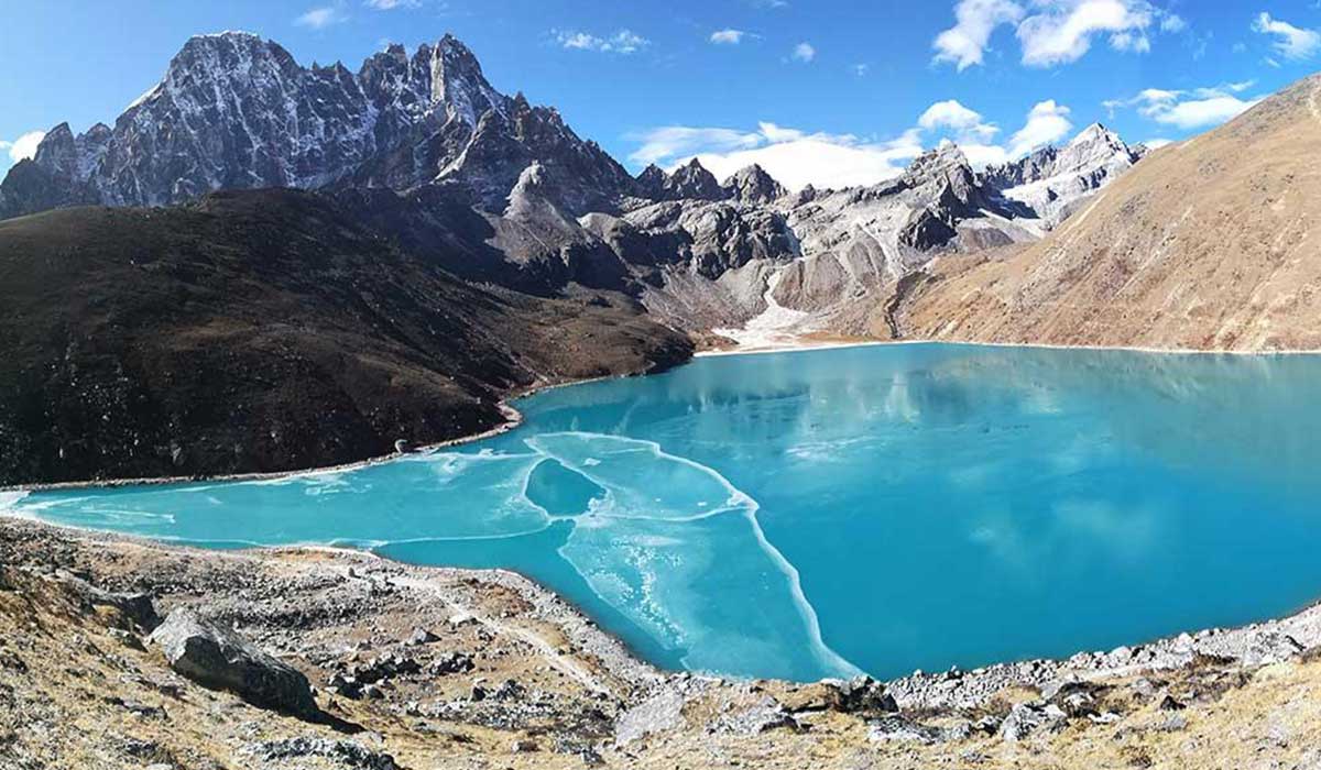
The glacier's massive western lateral moraine dams the valleys where the larger Gokyo Lakes formed. Seepage and streams from the glacier also feed the lakes. Without the glacier, the lakes wouldn't exist in their current form. The two are closely linked.
The easiest viewpoint is the moraine ridge just east of Gokyo village. For a bird's-eye view, climb Gokyo Ri (5,357 m). The Fifth Lake area offers views of the upper glacier. Trekkers crossing to the Cho La Pass walk directly over it.
Yes, trekkers crossing from Gokyo to Thangnak walk across the glacier's debris-covered surface. The crossing takes about 1.5–2.5 hours on loose rocks and uneven terrain. The route changes each season, so a guide is essential. Stay away from ice cliffs and pond edges.
Crossing the glacier can be challenging due to loose rocks, shifting paths and occasional rockfall. With an experienced guide and careful walking, it's generally safe for fit trekkers. Avoid crossing in poor visibility or bad weather. Trekking poles help with balance.
Yes, the Ngozumpa Glacier is thinning and shrinking, like many Himalayan glaciers. Meltwater collects in surface ponds and growing lakes such as Spillway Lake. Exposed ice cliffs melt and collapse. Scientists study it to understand climate change in the Himalaya.
The Gokyo Lakes Trek passes right beside the glacier. The Gokyo–Cho La–EBC trek and the Everest Three High Passes Trek include a glacier crossing. The Renjo La Pass trek offers views of it from above. All routes require entry into Sagarmatha National Park.
No separate glacier permit is needed. You only need the Sagarmatha National Park entry permit and the Khumbu Pasang Lhamu Rural Municipality permit. Both currently cost NPR 3,000 for foreign nationals. They're checked at Lukla and Monjo.
The best times are autumn (September–November) and spring (March–May). Autumn offers the clearest skies and best visibility. Spring has milder temperatures and good morning views. Winter is very cold, and the monsoon brings clouds and rain.
The glacier extends from high on the slopes of Cho Oyu and Gyachung Kang down to around 4,650 metres at its lowest point. Its accumulation zones lie much higher, fed mainly by avalanches. Around Gokyo, the glacier surface lies at roughly 4,700–4,800 metres. Altitude awareness is essential when visiting.
You can see Everest from viewpoints near the glacier, especially Gokyo Ri and the Fifth Lake area. From Gokyo Ri, Everest, Lhotse, Makalu and Cho Oyu rise above the glacier and lakes. Views are clearest early in the day. It's one of the most spectacular panoramas in Nepal.
The Ngozumpa Glacier is one of the Himalaya's most awe-inspiring natural wonders. Stretching for 36 kilometres beneath Cho Oyu, this vast river of ice and rock has shaped the Gokyo Valley, created the famous Gokyo Lakes and continues to transform the landscape today. Standing on the moraine ridge above it, hearing the ice crack and watching boulders shift, you'll feel the raw power of nature and see firsthand how climate change is reshaping the world's highest mountains.
Take time to explore its viewpoints, admire its turquoise ponds and dramatic ice cliffs, and enjoy the panorama from Gokyo Ri. With experienced local guides and well-planned itineraries, Nepal Trip Services will help you discover the Ngozumpa Glacier and the wider Gokyo Valley safely and unforgettably.
Discover more articles that match your interests! Explore these similar blogs packed with insights, tips, and stories to keep you inspired.
Explore Nepal\'s Gokyo Valley: sacred turquoise lakes, Gokyo Ri, Ngozumpa Glacier, Sherpa villages, routes, best time, p...
Discover the Dudh Koshi River, Nepal\'s "Milk River" of Everest: its source, bridges, villages, trekking routes, best ti...
Explore Dole (4,040 m), the first stop in Nepal\'s Gokyo Valley. Discover routes, teahouses, mountain views, altitude ti...
Explore Machhermo (4,470 m), the key acclimatisation stop before Gokyo. Discover routes, teahouses, Cho Oyu views, altit...
Discover Nepal\'s sacred Gokyo Lakes: all six lakes explained, Gokyo Ri, routes, best time, permits, altitude tips & how...
Climb Gokyo Ri (5,357 m) for one of Nepal\\'s best Everest panoramas. Route, timing, difficulty, sunrise tips, views, pe...