Dole, Nepal: Complete Travel & Trekking Guide
By Nepal Trip Services On 01 Oct 2026
By Nepal Trip Services On 01 Oct 2026

After the long climb from Namche Bazaar, the steep drop to the river at Phortse Thanga and another steady ascent through rhododendron and birch forest, the trees finally begin to thin. Ahead, a handful of stone lodges appear on a quiet hillside shelf, prayer flags flapping in the cold mountain breeze. Yaks graze nearby, and to the north, the valley opens toward the distant giant of Cho Oyu. This is Dole, the first overnight stop in the Gokyo Valley and the place where many trekkers spend their first night above 4,000 metres. This complete guide from Nepal Trip Services covers Dole's location, altitude, routes, accommodation, mountain views and practical tips for your journey on the Gokyo Lakes Trek.
Dole is a small village in the Khumbu region of Nepal, lying in the Dudh Koshi River valley just north of Khumjung and south of Machhermo. It sits inside Sagarmatha National Park, a UNESCO World Heritage Site, on the main trail toward the Gokyo Lakes.
Like many settlements in the upper Khumbu, Dole began as a seasonal yak-herding pasture (kharka). Today, it's a small cluster of family-run Sherpa teahouses that serve trekkers heading to Gokyo, Gokyo Ri and the Cho La Pass.
| Detail | Information |
|---|---|
| Location | Gokyo Valley, Khumbu region, Solukhumbu District, Nepal |
| Altitude | About 4,040 m (13,255 ft); sources range from ~4,010 to 4,200 m |
| Protected Area | Sagarmatha National Park |
| Valley | Upper Dudh Koshi River valley |
| Famous For | First overnight stop in the Gokyo Valley, forest-to-alpine transition |
| Previous Stop | Namche Bazaar (3,440 m) |
| Next Stop | Machhermo (~4,470 m) |
| Walking Time from Namche | 5–6 hours |
| Accommodation | A handful of basic teahouses |
| Permits | Sagarmatha National Park & Khumbu Pasang Lhamu permits |
| Best Time to Visit | March–May & September–November |
Altitude note: Wikipedia gives Dole's altitude as 4,038 m and notes that many trekking maps incorrectly list it as 4,200 m. Some itineraries also show 4,110 m.
Dole plays a key role in safe trekking in the Gokyo Valley:
| Section | Details |
|---|---|
| Namche → Kyangjuma | Gentle walk with views of Ama Dablam and Thamserku |
| Kyangjuma → Mong La (~3,975 m) | Steep climb to a ridge-top viewpoint with a chorten |
| Mong La → Phortse Thanga (~3,680 m) | Steep descent to the Dudh Koshi River |
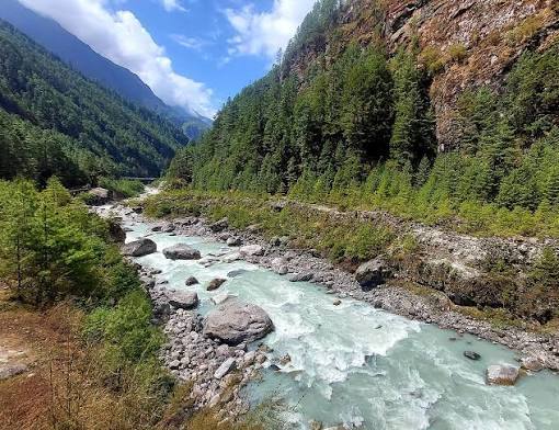
| Phortse Thanga → Dole (~4,040 m) | Steep climb through rhododendron, birch and juniper forest |
| Total | About 11–12 km, 5–6 hours |
At Phortse Thanga, the trail splits: the higher trail leads into the Gokyo Valley, while the lower path continues to Phortse village. Trekkers bound for Gokyo take the higher route toward Dole.
On the way back from Gokyo, many itineraries stop in Dole or Machhermo before continuing down to Namche Bazaar.
Dole is surrounded by impressive peaks:
| Mountain | Height | View |
|---|---|---|
| Cho Oyu | 8,188 m | Rising at the head of the valley to the north |
| Thamserku | 6,623 m | Behind you down the valley |
| Kangtega | 6,783 m | Dramatic peak to the south |
| Khumbila | 5,761 m | Sacred mountain of the Khumbu, nearby |
| Taboche (Tawache) | 6,495 m | Striking peak across the valley |
| Ama Dablam | 6,812 m | Seen on the way from Mong La |
Morning light on Thamserku and Kangtega from Dole is especially beautiful.
Dole lies at a fascinating ecological boundary where forest meets alpine landscape:
Dole has only a handful of teahouses, simple stone and wooden lodges run by Sherpa families.
| Facility | Details |
|---|---|
| Rooms | Basic twin-sharing rooms with blankets |
| Bathrooms | Mostly shared; squat or Western toilets |
| Hot Showers | Limited, usually for a fee |
| Charging | Available, often solar-powered and paid |
| Wi-Fi | Limited, usually through paid prepaid cards |
| Dining Hall | Warm communal room with a central stove |
The dining room stove is the heart of evening life in Dole, where trekkers gather to warm up, eat and share stories. Bring a warm sleeping bag, as rooms are unheated and nights are cold.
Teahouse menus are simple but filling:
Tip: Choose vegetarian meals at this altitude, as meat is carried up for days without refrigeration.
Dole is the first night above 4,000 m for most trekkers, so take altitude seriously:
| Season | Months | Day / Night (Approx.) | Conditions |
|---|---|---|---|
| Spring | March – May | 8–16°C / -5–2°C | Blooming rhododendrons, pleasant days |
| Monsoon | June – August | 12–18°C / 3–8°C | Rain, clouds and muddy trails |
| Autumn | September – November | 7–14°C / -8–0°C | Clear skies, best mountain views |
| Winter | December – February | 0–8°C / -15 – -8°C | Very cold, possible snow, few trekkers |
Best overall: October–November for views, March–April for rhododendrons.
| Permit | Foreign Nationals |
|---|---|
| Sagarmatha National Park Entry Permit | NPR 3,000 |
| Khumbu Pasang Lhamu Rural Municipality Permit | NPR 3,000 |
Permits are checked at Lukla and Monjo before you reach Dole.
| Trek | Duration | Max Altitude |
|---|---|---|
| Gokyo Lakes Trek | 12 days | 5,357 m (Gokyo Ri) |
| Everest Three High Passes Trek | 18–20 days | 5,535 m |
| Gokyo & Everest Base Camp via Cho La Trek | 15–18 days | ~5,545 m |
| Renjo La Pass Trek | 14–16 days | 5,360 m |
Spend a peaceful night in Dole and continue to the turquoise lakes and Everest panoramas of Gokyo Ri on our 12-day Gokyo Lakes Trek. For a classic Himalayan adventure, follow the trail to the foot of the world's highest peak on the Classic Everest Base Camp Trek. Experienced trekkers can take on the Everest Three High Passes Trek, crossing Kongma La, Cho La and Renjo La, while those seeking a shorter journey can enjoy stunning views on the Everest View Trek. Explore all our Everest Region adventures, and plan your perfect trip with our Trip Planner.
Dole is a small village in the Khumbu region of northeastern Nepal, inside Sagarmatha National Park. It lies in the upper Dudh Koshi valley, north of Khumjung and south of Machhermo. It's the first major stop on the trail into the Gokyo Valley. Most trekkers reach it from Namche Bazaar.
Dole sits at about 4,040 metres (13,255 ft) above sea level. Some sources and maps list higher figures, such as 4,110 or 4,200 metres. It's usually the first overnight stop above 4,000 metres on the Gokyo route. Proper acclimatisation is important here.
The trek from Namche Bazaar to Dole takes about 5–6 hours and covers around 11–12 km. The route climbs to Mong La, descends to Phortse Thanga and then climbs again to Dole. It's one of the more demanding days on the Gokyo trek. Walking slowly helps with acclimatisation.
Yes, Dole has a handful of basic teahouses run by Sherpa families. Rooms are simple twin-sharing with blankets, and bathrooms are mostly shared. Dining halls are warmed by a central stove. Facilities are more basic than in Namche Bazaar.
Some trekkers may feel mild altitude symptoms in Dole, as it's often the first night above 4,000 metres. Walking slowly, staying hydrated and avoiding alcohol reduce the risk. Watch for headache, nausea or dizziness. Inform your guide if symptoms appear.
From Dole, you can see Thamserku, Kangtega, Khumbila and Taboche, with Cho Oyu rising at the head of the valley. Ama Dablam is visible from Mong La on the way. Morning light offers the clearest views. The scenery becomes more dramatic as you continue north.
Machhermo is about 7 km from Dole, a walk of around 4–5 hours. The trail climbs gradually through yak pastures, passing Lhabarma and Luza. Views of Cho Oyu improve along the way. It's a shorter day to help with acclimatisation.
Yes, most teahouses offer charging, usually solar-powered and paid. Wi-Fi is limited and often available through prepaid data cards. Connections can be slow or unreliable. A power bank is highly recommended.
The best times are autumn (September–November) and spring (March–May). Autumn offers clear skies and mountain views, while spring brings rhododendron blooms. Winter is very cold with fewer trekkers. The monsoon brings rain and clouds.
There are no ATMs in Dole, and the nearest are in Namche Bazaar and Lukla. Teahouses sell basic snacks and drinks at higher prices. Bring enough Nepalese rupees for the entire Gokyo section. Plan ahead for personal supplies.
You may see Himalayan tahr, musk deer and the colourful Danphe pheasant around Dole. The forests below the village are home to many bird species. Yaks graze on nearby pastures. Spring is a great time for wildlife and flowers.
Yes, you need the Sagarmatha National Park entry permit and the Khumbu Pasang Lhamu Rural Municipality permit. Both currently cost NPR 3,000 for foreign nationals. Permits are checked at Lukla and Monjo. Trekking companies usually arrange them in advance.
Dole is cold at night year-round due to its altitude. In winter, night temperatures can drop to around -15°C, while autumn nights are often below freezing. Daytime temperatures are milder, especially in spring. Pack warm layers and a four-season sleeping bag.
Yes, many trekkers stay in Dole or Machhermo on the return from Gokyo. Descending to Dole makes the final walk to Namche Bazaar shorter. Your itinerary may vary depending on pace and weather. Your guide will plan the best overnight stops.
Dole lies on the Gokyo Lakes Trek and is also used on longer routes like the Everest Three High Passes Trek, the Gokyo–Cho La–EBC trek and the Renjo La Pass trek. It's the main gateway village into the Gokyo Valley. Most trekkers heading to Gokyo stop here. It's an important acclimatisation point.
Dole may be small, but it marks an important milestone on any Gokyo adventure. Here, the forest ends and the high Himalayan world begins, with yak pastures, cold clear air and the first distant glimpse of Cho Oyu. For many trekkers, it's their first night above 4,000 metres, a quiet place to rest, acclimatise and gather around a warm stove with fellow adventurers before continuing toward the turquoise lakes.
Take your time in Dole. Walk slowly, drink plenty of water and enjoy the peaceful atmosphere and mountain views. With experienced local guides and carefully planned itineraries, Nepal Trip Services will help you journey safely through Dole and deep into the heart of the Gokyo Valley.
Discover more articles that match your interests! Explore these similar blogs packed with insights, tips, and stories to keep you inspired.
Explore Nepal\'s Gokyo Valley: sacred turquoise lakes, Gokyo Ri, Ngozumpa Glacier, Sherpa villages, routes, best time, p...
Discover the Dudh Koshi River, Nepal\'s "Milk River" of Everest: its source, bridges, villages, trekking routes, best ti...
Explore Machhermo (4,470 m), the key acclimatisation stop before Gokyo. Discover routes, teahouses, Cho Oyu views, altit...
Discover Nepal\'s sacred Gokyo Lakes: all six lakes explained, Gokyo Ri, routes, best time, permits, altitude tips & how...
Climb Gokyo Ri (5,357 m) for one of Nepal\\'s best Everest panoramas. Route, timing, difficulty, sunrise tips, views, pe...
Explore the Ngozumpa Glacier, the longest in the Himalaya. Discover its size, Spillway Lake, viewpoints, glacier crossin...