
Tadapani, Nepal: Complete Travel & Trekking Guide
By Nepal Trip Services On 01 Oct 2026

By Nepal Trip Services On 01 Oct 2026
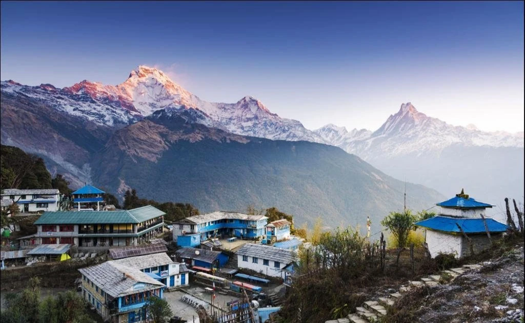
Deep in the rhododendron forests of the Annapurna foothills, the trail opens into a small clearing. A handful of teahouses stand on the ridge, prayer flags flutter in the breeze, and suddenly, right above the treetops, the sharp, sacred summit of Machhapuchhre (Fishtail) fills the sky beside the snowy bulk of Annapurna South. Welcome to Tadapani, one of the most peaceful and photogenic stops on the classic Poon Hill and Annapurna trekking routes. It's a place where you don't need to climb before dawn to see the sunrise; the mountains are waiting outside your lodge door. This complete guide from Nepal Trip Services covers Tadapani's location, altitude, history, mountain views, trekking routes, accommodation, best time to visit and practical tips.
Tadapani is a small forest village in the Annapurna Conservation Area, located high in the foothills above the Gurung village of Ghandruk. It sits on the ridge separating the Modi Khola valley from the Ghorepani side of the range. At about 2,630 metres, it's a popular overnight stop on the Ghorepani Poon Hill Trek and a key junction for trekkers heading toward Annapurna Base Camp.
Unlike larger villages, Tadapani is quiet and intimate, made up mainly of family-run teahouses surrounded by dense forest. Its main attraction is the close-up view of Machhapuchhre, Annapurna South and Hiunchuli, especially magical at sunrise and sunset.
| Detail | Information |
|---|---|
| Location | Annapurna Conservation Area, Kaski District, Nepal |
| Altitude | About 2,630 m (8,629 ft); sources range from ~2,590 to 2,700 m |
| Meaning of Name | "Far Water" |
| Famous For | Sunrise views of Machhapuchhre & Annapurna South, rhododendron forests |
| Main Trek Routes | Ghorepani Poon Hill Trek, Annapurna Base Camp Trek |
| Nearest City | Pokhara |
| Distance from Ghorepani | About 9–10 km (5–6 hours) |
| Distance from Ghandruk | About 6–8 km (3–4 hours uphill / 2–3 hours downhill) |
| Accommodation | Teahouses and lodges |
| Permits | ACAP & TIMS Card |
| Best Time to Visit | March–May & September–November |
The name Tadapani comes from two Nepali words: tada (far) and pani (water). It literally means "far water", from the days when villagers had to walk a long way to fetch water. Today, water supply has improved, and teahouses have reliable access, but the name remains a reminder of how challenging life on the ridge once was.
Tadapani is an important crossroads where several of the Annapurna region's classic trails meet.
| Direction | Destination | Trek Route |
|---|---|---|
| West | Ghorepani & Poon Hill | Ghorepani Poon Hill Trek |
| South-East | Ghandruk | Return route toward Pokhara |
| North-East | Chhomrong via Chuile & Gurjung | Annapurna Base Camp Trek |
| North | Khopra Ridge & Khayer Lake | Off-the-beaten-path Khopra Danda Trek |
This makes Tadapani a perfect place to link Poon Hill with Annapurna Base Camp or to explore quieter alternative routes.
Tadapani's ridge-top clearing offers some of the closest and most dramatic mountain views on the Poon Hill loop.
| Mountain | Height | Highlight |
|---|---|---|
| Machhapuchhre (Fishtail) | 6,993 m | Sacred peak towering directly above the forest |
| Annapurna South | 7,219 m | Massive snowy wall to the north |
| Hiunchuli | 6,441 m | Sharp summit beside Annapurna South |
| Gangapurna | 7,455 m | Visible on clear days |
Unlike Poon Hill, where you climb in the dark to reach the viewpoint, at Tadapani the view is right outside your teahouse. Step out at first light with a cup of tea and watch Machhapuchhre and Annapurna South glow pink, then gold, above the trees, often with far fewer people around.
The main highlight. Enjoy the changing colours on Machhapuchhre and Annapurna South from your lodge terrace, with no early-morning climb required.
Tadapani is surrounded by tall forests of rhododendron, oak and magnolia. In spring (March–April), the trails glow with red, pink and white blooms, creating one of the most beautiful forest walks in Nepal.
The forests around Tadapani are rich in birdlife. Listen for the call of the Satyr Tragopan, a striking red pheasant, along with laughing thrushes, sunbirds and other Himalayan species.
On the trail toward Ghorepani, the ridge near Deurali (about 3,090 m) offers wide views of Dhaulagiri, Annapurna and Machhapuchhre, a great side highlight for photographers.
Tadapani's small size makes evenings peaceful. Gather around the dining-hall stove, enjoy a hot meal and share trail stories with fellow trekkers.
From misty forest trails and moss-covered trees to dramatic mountain sunrises, Tadapani is a dream for nature and landscape photographers.
| Detail | Information |
|---|---|
| Distance | About 9–10 km |
| Duration | 5–6 hours |
| Route | Ghorepani → Deurali ridge (~3,090 m) → Banthanti → Tadapani |
| Highlights | Ridge-top views, dense forest, streams and waterfalls |
The trail first climbs to the scenic Deurali ridge, then descends through thick rhododendron forest, crossing small streams before a final short climb to Tadapani.
| Detail | Information |
|---|---|
| Distance | About 6–8 km |
| Duration | 3–4 hours uphill |
| Route | Ghandruk → Bhaisi Kharka → Tadapani |
| Highlights | Gurung villages, terraced fields, forest trails |
Trekkers returning from Annapurna Base Camp or heading there can link Tadapani and Chhomrong via Chuile and Gurjung, a beautiful route above the Modi Khola valley.
On our 7-day Poon Hill Trek, Tadapani is the overnight stop after the famous Poon Hill sunrise:
| Day | Route | Altitude |
|---|---|---|
| Day 3 | Pokhara → Ulleri (drive) → Ghorepani | 2,885 m |
| Day 4 | Poon Hill sunrise → Tadapani | 2,640 m |
| Day 5 | Tadapani → Ghandruk → Pokhara (drive) | 2,012 m |
Tadapani has a small cluster of family-run teahouses, most with terraces or dining halls facing Machhapuchhre.
| Facility | Details |
|---|---|
| Rooms | Simple twin-sharing rooms with beds and blankets |
| Bathrooms | Mostly shared; a few attached options |
| Hot Showers | Solar or gas, often for a small fee |
| Wi-Fi & Charging | Available, usually for a small fee |
| Dining Hall | Warm communal hall with a stove |
Tip: Because Tadapani is small, rooms can fill quickly in peak seasons. Trekking with an agency ensures your bed is reserved.
Teahouses serve hearty meals to fuel your trek:
| Season | Months | Day / Night (Approx.) | Conditions |
|---|---|---|---|
| Spring | March – May | 12–20°C / 0–6°C | Rhododendrons in bloom, pleasant days |
| Monsoon | June – August | 15–22°C / 10–14°C | Rain, mist, leeches on forest trails |
| Autumn | September – November | 10–18°C / 0–6°C | Clearest skies, best mountain views |
| Winter | December – February | 6–12°C / -4–2°C | Cold, clear and quiet |
Best overall: October–November for views and March–April for rhododendrons.
Tadapani lies within the Annapurna Conservation Area, so you'll need:
Our trek packages include both permits.
Tadapani is a highlight of our 7-day Poon Hill Trek and a gateway to bigger Annapurna adventures. Explore the Annapurna Region Treks, including the Annapurna Base Camp Trek, Mardi Himal Trek and Annapurna Circuit Trek. Plan your own journey with our Trip Planner.
Tadapani is in Kaski District of western Nepal, inside the Annapurna Conservation Area. It sits on a forested ridge above the Gurung village of Ghandruk, between the Modi Khola valley and the Ghorepani side of the range. It lies on the classic Ghorepani Poon Hill trekking loop. Pokhara is the nearest city.
Tadapani sits at about 2,630 metres (8,629 ft) above sea level. Some sources list slightly different figures, from around 2,590 to 2,700 metres. This altitude is low enough that altitude sickness is rarely a concern. Nights can still be cold, especially in winter.
Tadapani means "far water" in Nepali, from tada (far) and pani (water). The name comes from the days when villagers had to walk a long distance to fetch water. Water access has since improved. The name remains a reminder of the village's history.
From Tadapani, you can see Machhapuchhre (Fishtail), Annapurna South, Hiunchuli and, on clear days, Gangapurna. Machhapuchhre appears especially close and dramatic. Sunrise and sunset are the best times for views. The mountains are visible right from most teahouses.
Tadapani is about 9–10 km from Ghorepani, a walk of around 5–6 hours. The trail climbs to the Deurali ridge before descending through rhododendron forests. It's one of the most scenic sections of the Poon Hill loop. Most trekkers walk this section after the Poon Hill sunrise.
Tadapani is about 6–8 km from Ghandruk. The walk takes around 3–4 hours uphill from Ghandruk or 2–3 hours downhill from Tadapani. The trail passes through forests and small settlements. It's a pleasant and manageable walk for most trekkers.
Yes, Tadapani has several family-run teahouses offering simple twin-sharing rooms, shared bathrooms and warm dining halls. Many lodges have terraces facing Machhapuchhre and Annapurna South. Hot showers, Wi-Fi and charging are usually available for a small fee. Booking ahead is helpful in peak seasons.
Both offer amazing sunrises, but they're different experiences. Poon Hill provides a wide panorama including Dhaulagiri, while Tadapani offers close-up views of Machhapuchhre and Annapurna South. At Tadapani, you can watch from your lodge without an early climb. Many trekkers enjoy both on the same trek.
Yes, Tadapani connects to Chhomrong via Chuile and Gurjung, which leads into the Annapurna Sanctuary toward Annapurna Base Camp. This makes it easy to combine Poon Hill with ABC. The combined trek typically adds several days. It's a popular route for trekkers wanting both experiences.
The best times are spring (March–May) and autumn (September–November). Spring brings blooming rhododendrons, while autumn offers the clearest mountain views. Winter is quiet but cold. The monsoon brings rain, clouds and leeches on forest trails.
Yes, Tadapani is suitable for beginners, as it's part of the easy-to-moderate Poon Hill Trek. The trails involve some uphill and downhill sections but no technical challenges. The moderate altitude keeps risks low. A steady pace and basic fitness are enough.
Yes, you need the ACAP permit and a TIMS card, as Tadapani lies in the Annapurna Conservation Area. Permits are checked at points along the trail. Trekking companies usually arrange them in advance. Keep them with you at all times.
There are no ATMs in Tadapani, so bring enough cash from Pokhara. Teahouses sell basic snacks, drinks and toiletries, but options are limited. Prices are higher than in Pokhara due to transport costs. Plan ahead for any personal supplies.
Most teahouses offer Wi-Fi, usually for a small fee, and mobile coverage is often available. Connections may be slow or patchy, especially in bad weather. Charging is available but may cost extra. Carry a power bank as a backup.
The forests around Tadapani are home to many birds, including the colourful Satyr Tragopan, laughing thrushes and sunbirds. You may also spot langur monkeys and other small mammals. Spring is a great time for birdwatching. Keep noise low to increase your chances of sightings.
Tadapani may be small, but it leaves a big impression. Surrounded by ancient rhododendron forests and watched over by the sacred peak of Machhapuchhre, it offers a peaceful contrast to busier trekking villages. Here, the mountains are close, the evenings are quiet, and the sunrise arrives without a pre-dawn climb, just you, a warm cup of tea and the Himalayas lighting up above the trees.
Whether you're continuing to Ghandruk, heading toward Annapurna Base Camp or simply resting after the Poon Hill sunrise, Tadapani is a place to slow down and soak in the beauty of the Annapurna region. For a safe, well-planned trek with experienced local guides, Nepal Trip Services will help you experience Tadapani and the wider Annapurna trails at their very best.
Discover more articles that match your interests! Explore these similar blogs packed with insights, tips, and stories to keep you inspired.
Plan your Ulleri visit: climb the famous stone staircase, meet Magar culture & enjoy Annapurna views on the way to Ghore...
Suggested Meta Description: Explore Ghorepani (2,874 m), gateway to Poon Hill sunrise. Discover its history, teahouses, ...
Plan your Poon Hill trek: sunrise at 3,210 m over Dhaulagiri & Annapurna, routes, itineraries, permits, best time, diffi...
Explore Tikhedhunga (1,540 m), riverside gateway to Ulleri\'s stone steps & Poon Hill. Routes from Nayapul, teahouses, b...
Discover the Magar people of Nepal: history, languages, festivals, Gurkha heritage, food, dress & where to experience Ma...
Plan your Kathmandu to Pokhara flight: airlines, daily schedule, ticket prices, baggage allowance, best seats for mounta...